Jerusalem, le Mur des Lamentations/ the Wailing Wall

Image

Jerusalem, le Mur des Lamentations/ the Wailing Wall

Le Mur des Lamentations au coeur de la Vieille ville de Jérusalem possède une dimension religieuse et politique, qui cristallise une partie de l’opposition entre Israéliens et Palestiniens. Il est considéré comme le principal lieu-saint pour les Juifs. L’autre côté du mur donne sur l’Esplanade des Mosquées, l’un des principaux lieux-saints de l’islam.

Cette année, les femmes ont réclamé l’égalité devant le Mur des Lamentations.

Voir le reportage de Radio-Canada:
http://www.radio-canada.ca/nouvelles/International/2013/05/10/008-jerusalem-juives-droit-priere-mur-lamentations-jerusalem.shtml

The Wailing Wall in the heart of the Old City of Jerusalem has a religious and political dimension, which crystallizes in the opposition between Israelis and Palestinians. It is considered the main holy place for Jews. The other side of the wall overlooking the Temple Mount, one of the main holy places of Islam.

See this interesting text editor’s most famous New York Times, Thomas L. FRIEDMAN:

See also this NYT article which shows the tension around the site:

The Washington Post has a series of articles on the Wailing Wall:

http://articles.washingtonpost.com/keyword/western-wall

Israel/Lebanon border in Metula

Image

Israel/Lebanon border in Metula

Située au nord du doigt de Galilée, à 600 mètres d’altitude, Metula est frontalière avec le Liban. Le passage de la frontière demeure impossible, le Liban ne reconnaît pas l’Etat israélien. Cependant, de nombreux éléments du paysage de la ville sont liés à la frontière: The Good Fence, qui était le point de passage entre 1976 et 2000 pour les employés (surtout des Maronites) qui vivaient au Liban et travaillaient en Israël; le Dado Panorama, qui offre une vue spectaculaire sur les villages libanais voisins et le point de passage, qui, lui demeure fermé.

Located in the north of the finger of Galilee, 600 meters above sea level, Metula is a border town with Lebanon. The border crossing remains impossible, as Lebanon doesn’t recognize the Israeli state. However, many elements of the landscape of the city are related to the border: The Good Fence, which was the crossing point between 1976 and 2000 for employees (mostly Maronites) who lived and worked in Lebanon in Israel ; the Dado Panorama , which offers a spectacular view of the neighboring Lebanese villages and the crossing point, which remains closed.

Togo-Ghana

Image

Togo-Ghana

La capitale togolaise, Lomé, est située à la frontière avec le Ghana. Ancienne colonie française, le Togo est francophone tandis que le Ghana (autrefois appelée Gold Coast) est anglophone. La frontière entre les deux Etats n’a pas pris en compte les langues locales, comme l’éwé, qui est parlé dans la région de Lomé et d’Aflao au Ghana.

Ci-dessus, le boulevard le long de la plage de Lomé qui mène au poste-frontière d’Aflao en janvier 2008.

Un poste frontalier commun est à l’étude:

http://koaci.com/articles-85699

The Togolese capital Lomé is located on the border with Ghana. As a former French colony, French is the official language in Togo while in Ghana (formerly Gold Coast) it is English. The border between the two states did not take into account local languages ​​such as Ewe, which is spoken on either side of the border, from Lomé to Aflao in Ghana.

Above, the boulevard along the beach that leads to Lomé border post Aflao.

A link about the porous border in Aflao:

http://graphic.com.gh/archive/features/aflao-a-border-town-with-porous-borders.html

Estonia/Russia, the border in Narva

Image

Estonia/Russia, the border in Narva

Le fleuve Narva délimite l’Estonie sur la gauche de la Russie, avec la ville d’Ivangorod (sur la droite). Cette dernière faisait auparavant partie de Narva, notamment lors de l’indépendance de l’Estonie dans l’entre-deux-guerres. Mais en 1945, Ivangorod est intégrée à la Russie: en 1991, cette limite devient une frontière d’Etat lors de la dissolution de l’Union soviétique. Avec l’élargissement européen, cette frontière a pris une nouvelle dimension puisqu’elle est depuis 2007 l’une des limites externes de l’espace Schengen. En conséquence, la population de Narva, très majoritairement composée de Russes, a plus de difficultés pour se rendre dans son pays d’origine.

Voir l’article de Pascal ORCIER de septembre 2009 dans Géoconfluences: franchir les frontières: mise en récits et en images. L’exemple des frontières entre la Russie et l’Union européenne:

http://geoconfluences.ens-lyon.fr/doc/typespace/frontier/FrontViv2.htm

Voir l’article du 29 mai 2011de Mediapart, sur les trafics à la frontière:

http://blogs.mediapart.fr/edition/wwwe-stoniefr/article/290511/narva-la-frontiere-des-petits-trafics

Voir le site Espaces transfrontaliers, sur la (faible) coopération transfrontalière entre l’Estonie et la Russie:

http://www.espaces-transfrontaliers.org/affiche_terri.php?affiche=territoire/terri_doc_ag_narva.html

Narva river separates Estonia (on the left) from the Russian town of Ivangorod (on the right). This latest used to be part of Narva, especially during the first Estonian state between the two World Wars. But in 1945, Ivangorod was integrated into Russia: when the Soviet Union split in 1991, this limit became an international border. Since 2004, it has been also an external limit of the European Union, as Estonia was part of the enlargment. In 2007, this border became an external border of the Schengen zone, making the crossing of the border more difficult for the population of Narva, which is mostly populated by Russians.

See the website of Espaces Transfrontaliers:

http://geoconfluences.ens-lyon.fr/doc/typespace/frontier/FrontViv2.htm

Also see a working paper from the Danish Institute for International Studies:

http://www.google.fr/url?sa=t&rct=j&q=&esrc=s&frm=1&source=web&cd=20&ved=0CHgQFjAJOAo&url=http%3A%2F%2Fmercury.ethz.ch%2Fserviceengine%2FFiles%2FISN%2F18672%2Fipublicationdocument_singledocument%2Fab16768b-e778-4f61-b8f2-4ad56dada7b0%2Fen%2FMarginality_Provinciality.pdf&ei=ptGDUsDLK4mI7AbDuoDgDg&usg=AFQjCNFNf-XI1c1xqPDuFqLp3VfZVo8EaQ

Looking into North Korea

Image

Jumelles pour apercevoir la Corée du Nord depuis l’Observatoire Odusan, l’un des endroits les plus touristiques le long de la DMZ coréenne. A cet endroit, les deux Corées sont séparées par l’Imjin.

Pour davantage de précisions, voir les posts précédents:

COREE: la DMZ, futur parc national?/KOREA: DMZ, future national park?

Corée/Korea

Looking into North Korea

Binoculars to look into North Korea from Odusan Observatory, one of the most touristic place along the Korean DMZ. At this point, Imjin River separates both Koreas.

For further explanations, also see some former posts:

COREE: la DMZ, futur parc national?/KOREA: DMZ, future national park?

Corée/Korea

Albania/Albanie

Image

Albania/Albanie

Vue de l’un des bunkers situé devant la propriété de l’ancien dictateur albanais, Enver Hodja. Du temps du communisme, pas moins de 700 000 bunkers étaient répartis dans l’ensemble du pays et présentés par le régime comme une protection contre les attaques nucléaires. Ce bunker symbolise désormais la tyrannie et se trouve sur l’une des principales avenues de Tirana. En arrière-plan, apparaît un morceau du mur de Berlin, qui rappelle que la chute du communisme en Europe a été de pair avec l’ouverture des frontières.

Voir l’article de Presse-Europe, publié le 3 août 2012:

http://www.presseurop.eu/fr/content/article/2462091-l-adieu-aux-bunkers-de-hoxha

Voir également le texte et les photos de David BREGER dans le Paris-Match du 17 août 2013:

http://youpress.fr/2013/11/albanie-le-bunker-se-vend-bien/

View of one of the bunker in front of former Albanian dictator’s property, Enver Hodja. Under communism, there were about 700 000 bunkers in the country, which were presented by the regime as a protection against nuclear attacks. The bunker appears now to be a symbol of tyranny and is shown on one of the main avenue in Tirana. In the background of the picture, a piece of the Berlin wall reminds the opening of most of borders in the European continent after the fall of communism.

See some pictures published in the Huffington Post, last March:

http://www.huffingtonpost.com/2013/03/18/albania-bunkers-enver-hoxha_n_2891096.html

See also this old but useful article from the NYT:

Israel/Lebanon

Image

Israel/Lebanon

Vue du village de Houla (Liban) depuis le kibboutz de Menara, au sommet d’une montagne entre la ville israélienne de Kyriat Shmona et le village de Houla.

La frontière reste fermée en raison du conflit entre le Hezbollah, groupe armé et religieux qui ne reconnaît pas l’existence d’un Etat juif en Palestine, et Israël.

Voir l’article du Monde du 7 août dernier:

http://www.lemonde.fr/proche-orient/article/2013/08/07/des-soldats-israeliens-blesses-lors-d-une-incursion-en-territoire-libanais_3458604_3218.html

View from the kibbutz of Menara at the top of the mountain between the Israeli town of Kyriat Shmona and the Lebanese village of Houla.

The border remains closed due to tensions between armed group Hezbollah, which is ruling most of South Lebanon and Israel.

Israel/Syria

Image

Israel/Syria

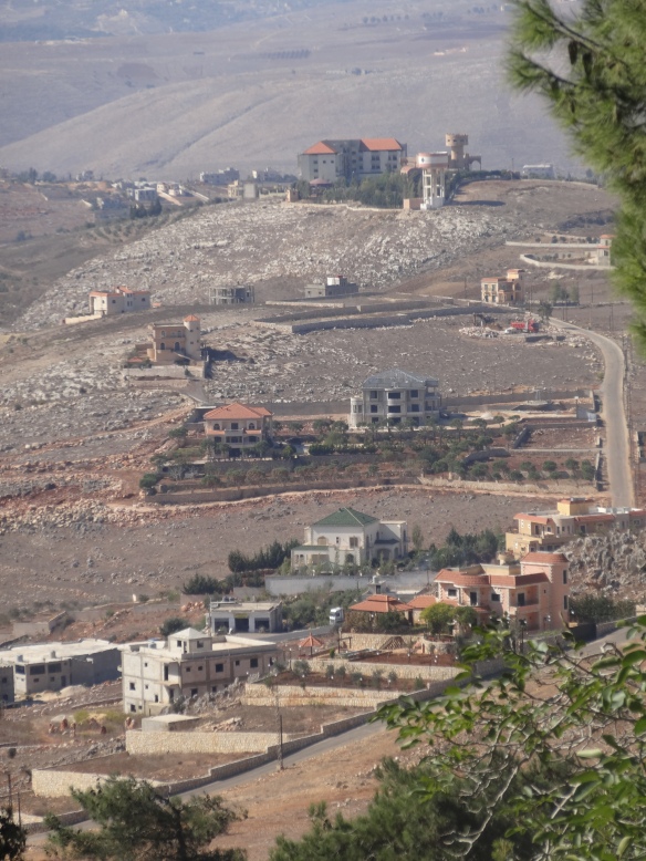
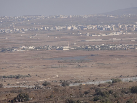
Vue de Kuneitra (Syrie) depuis le Golan, côté israélien. Depuis l’intrusion de l’Etat hébreu en 1967, le Golan est sous occupation israélienne.

Pour un rappel historique des faits et le poids des représentations géographiques des protagonistes, voir l’article de Michael F. Davies, géographe à l’université de Tours:

http://mappemonde.mgm.fr/num8/articles/art05404.html

Au premier plan, on aperçoit la zone démilitarisée avec la barrière de séparation.

La guerre en Syrie a d’ailleurs activé une nouvelle phase de construction pour mieux sécuriser la frontière, qui, indépendamment de la guerre, est fermée. La ville de Kuneitra (à 60 km au sud-ouest de Damas) est l’objet de combats violents entre les forces gouvernementales et celles que l’opposition hétéroclite. Du fait de la proximité de Kuneitra avec Israël, les effets des combats sont parfois ressentis au-delà de la zone démilitarisée.

Cf l’article de Libération du 28 août 2013:

http://www.liberation.fr/monde/2013/08/28/israel-se-prepare-a-un-possible-debordement-du-conflit-syrien_927704

Les Israéliens ont ouvert la frontière à quelques dizaines de blessés du conflit afin qu’ils puissent être soignés dans les hôpitaux du pays.

Voir: http://www.france24.com/fr/20130918-reportage-syrie-israel-hopitaux-ennemi-etat-hebreu-juif-bachar-al-assad-golan-onu-tsahal-focus-refugies

Sur le rôle d’Israël dans le conflit syrien, écouter le postcast de l’émission les Enjeux Internationaux sur France Culture du 27 juin 2013 avec l’intervention d’Alain DIECKHOFF:

http://www.franceculture.fr/emission-les-enjeux-internationaux-syrie-la-guerre-civile-vue-d%E2%80%99israel-2013-06-27

View of the Syrian city of Quneitra, from the Israeli side of the Golan. This region has been under Israeli occupation since 1967.

In the foreground you can see the DMZ with the separation barrier.

The war in Syria has also enabled a new phase of construction to better secure the border, regardless of the war is closed. The city of Quneitra (60 km southwest of Damascus) is the subject of fierce fighting between government forces and those of the so-called opposition.

See the article from the NYT, June 6th, 2013: http://www.nytimes.com/2013/06/07/world/middleeast/syrian-rebels-golan-heights.html?_r=0

Due to the proximity of Quneitra with Israel, the effects of the fighting are sometimes felt beyond the demilitarized zone.

See, http://www.reuters.com/article/2013/10/09/us-syria-crisis-israel-idUSBRE9980L820131009

The Israelis opened the border to a few dozen wounded conflict so they can be treated in hospitals.

See the article from the Jerusalem Post, Sept 12th, 2013:

http://www.jpost.com/Defense/Two-mortar-shells-from-Syria-land-in-Israeli-Golan-Heights-325948